Warning: I am not an expert or scholar of the American Civil War. Any mistakes are entirely mine. The use of Geographic Information System (GIS) and Lidar has great possibilities in discussing tactics, troop movement, topographic analysis, and cultural resource management of these important resources of American History.
The Civil War Battlefield of Petersburg, Virginia, is today a series of protected areas scattered across the landscape south of the city of Petersburg. This is the first of several blog posts about Lidar and this Battlefield. Inscribed into the landscape is the construction of Union and Confederate forces’ efforts to dig in: the Union laying siege, the Confederates defending the backdoor to Richmond, and the supply lines (railroad and dirt roads) into the Captial. The land remembers: both in the blood spilled, and the soil moved.
First, some comments about the Lidar data. Coverage of the battlefield varies from total lidar coverage to partial overflight. This is the case in many situations where you are using USGS Lidar data flights, where the initial Lidar flight mission is possibly a contract for floodplain data or a specific county area or a planning development zone, or there are restrictions on the data being in the public domain. In this first post, there are no restrictions to the data. Figure 1 represents the areas of NPS property covered in this and future Blogs. Because of the large amount of data generated by an overflight in the post-flight processing, the Lidar contractor typically “cuts” the data into “sheets,” making it easier for the end user to use specific areas without breaking their computers.
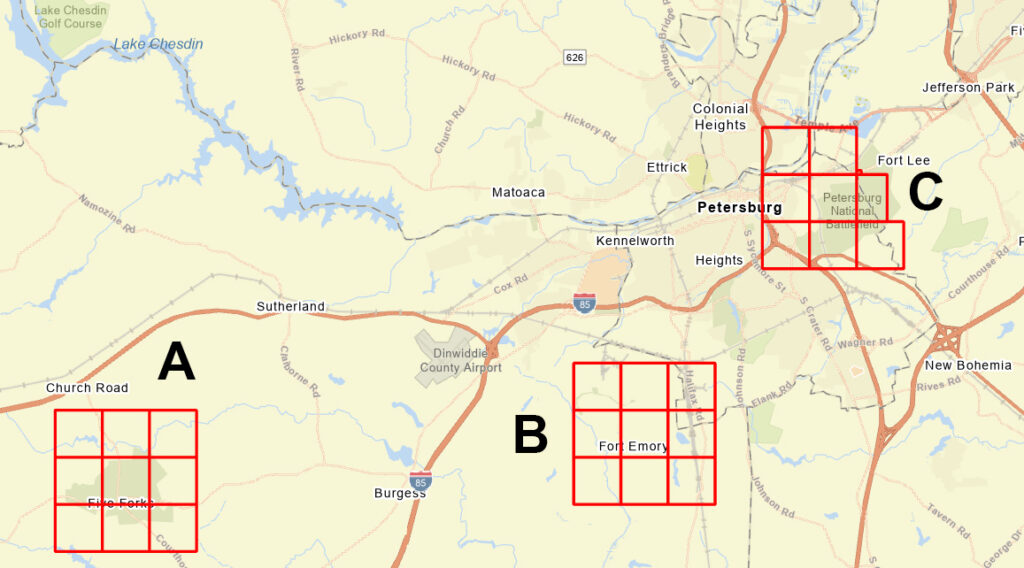
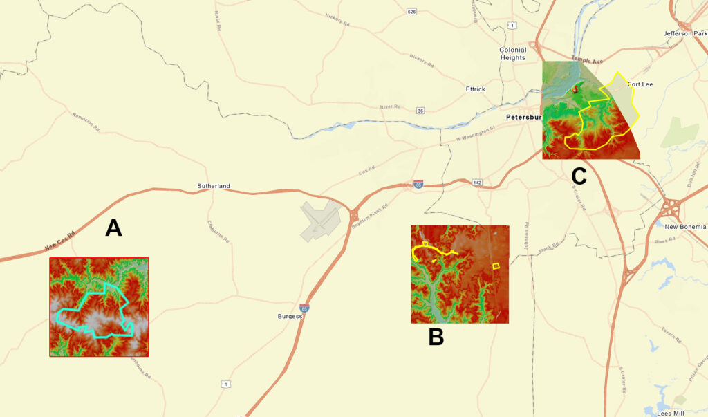
In this post, I am using lidar data from Area B (see figure 1). Area B includes nine sheets of “cut” data. Those nine sheets combined have 3 GB of data with 115,201,131 data points! Of course, not all the data points were used. Many first returns were tops of trees or buildings. All those data points were removed, as were water, unassigned, noise, rail, high noise, etc., and the total ground data points used were 29,987,747. Below, Figure 2 shows the DEM (Digital Elevation model) for each area.
The siege of Petersburg occurred over a year, prefiguring trench warfare in World War I (Indeed, troops were trained here in some of these trenches before going overseas to fight in France during World War I). This siege continued from June 18, 1864, when the Union first attempted to capture Peterburg, to the Union victory in the Breakthrough on April 2, 1865.
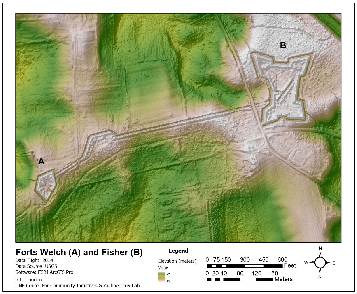
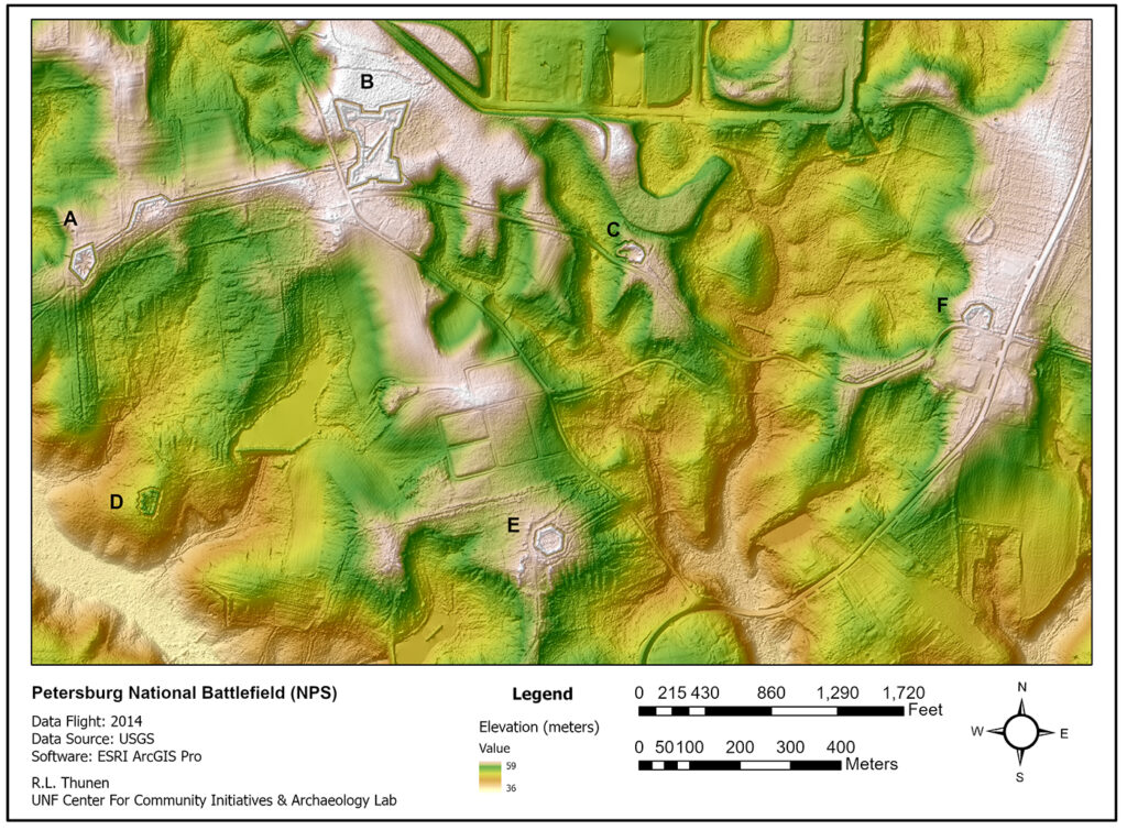
Figure 3 (below) displays the six earthen Union forts from the central sections of Area B (known as the western front of the Union line or the Federal Fish Hook Line) that are the subject of this post. These forts were built as part of the Union offensive to put pressure on Petersburg and Richmond and cut the supply roads and the railroad tracks into Richmond. The landscape at the time included the “Siege of Petersburg,” forts, and cannon batteries; both sides constructed trenches as part of the overall battle plan. The Union and the Confederates both tried to outflank the fixed trench positions: the siege lasted 292 days, with the constant creation of additional trenches and earthworks. Figure 3 displays six of the Union Forts as well as one battery (to the right of Fort Welch (A) and the trenches between A & B and north of the road between B & C). Figure 4 shows the area around Fort Welch and Fort Fisher.
Fort Fisher was the largest Union earthwork fort constructed during the siege of Petersburg, named for Lt. Otis Fisher, who was killed during the 5th Offensive at Peebles Farm, Petersburg. All Union forts at Petersburg were named for individuals killed during the prolonged siege of Petersburg. Fort Fisher’s construction started as a minor square earthwork (Oct 3-18, 1864). As the defending position of the Union’s western flank, it was reconfigured and enlarged (January-March 1865) to reflect its strategic importance in the Union line. The Fort supported 19 field guns and three powder magazines and could house 300 men. It became known as the Fish Hook in the Union defensive line. To the left, Fort Welch (A) was connected by an umbilical cord of the trench line that included an Artillery Battery. Fort Welch was constructed in October (3-10) 1864 to strengthen the western front of the Union line. During its occupation, the Fort had positions for nine field guns with a least one powder magazine, housing up to 175 men.
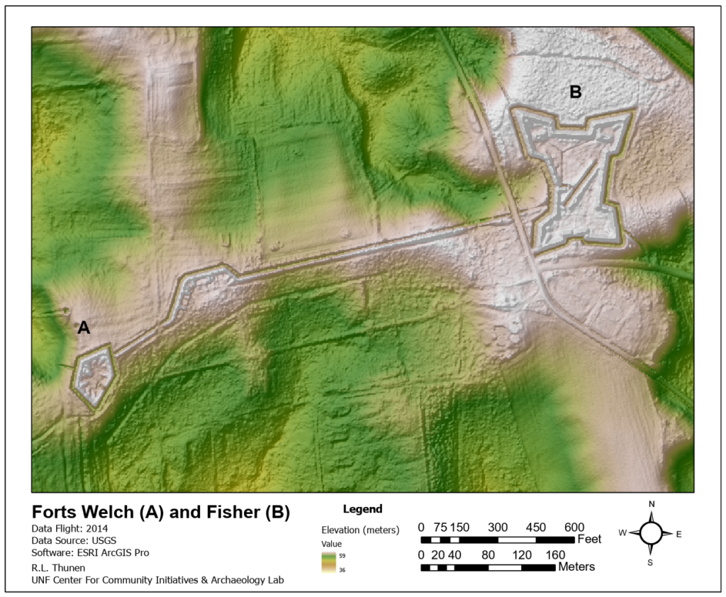
Figure 5 defines two smaller but geometrically interesting Union forts in the Fish Hook. Fort Gregg (D); yes, there are both Union and Conferedare forts named Gregg at Petersburg. NPS describes the Union Fort as a six-sided redoubt with a dentate front, another way of saying a zigzag defensive position. Constructed on Oct. 3-27, 1864, it housed two to four artillery pieces during its use. From the Lidar, you can see its importance placed on a topographic point above Arthur Swamp (sic).
Fort Wheaton (E) is a re-purposed Confederate Fort named Fort Archer. Built by the Confederates in August 1864 and captured on September 30, 1864, the Union force finished the Fort’s construction. A six-side readout with positions for six guns, this Fort was part of the second line of defense for the Union Army.

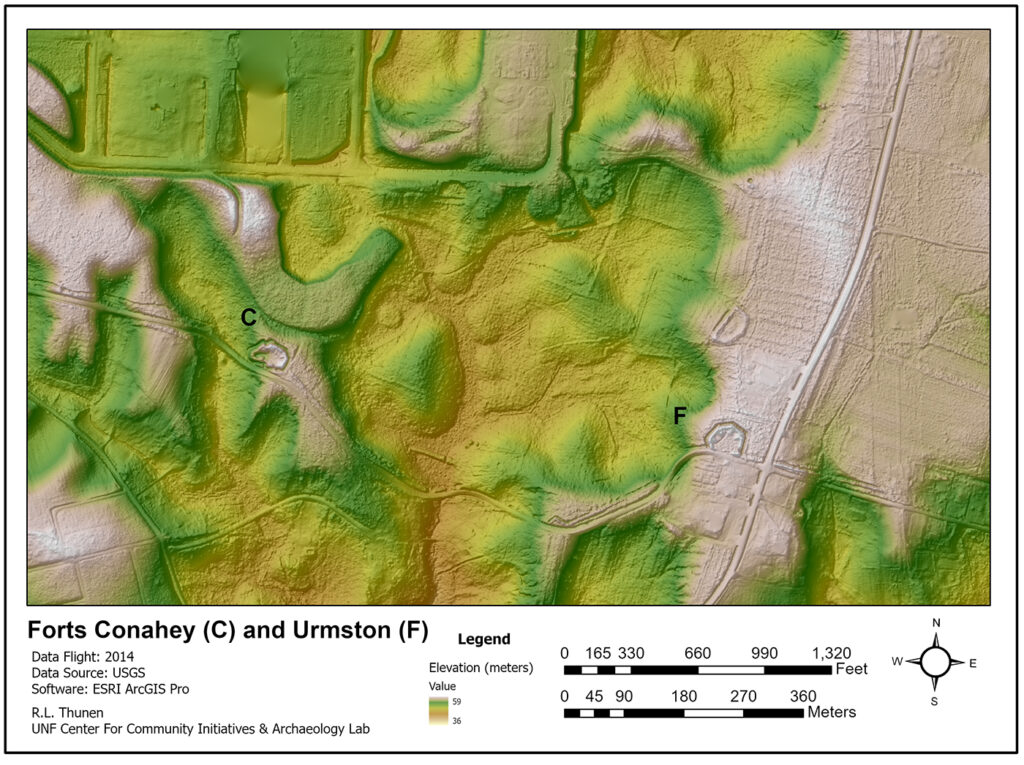
Fort Conahey (C) is a Union earthwork built October 3-26,1864. The Fort is ovoid in redoubt with a dentate front along the north edge. Built to house 11 field guns of various types. Rifle pits (Trenches) were placed west and east of the forts to support the artillery. They can be seen in the Lidar just north of the road. Borrowing a quote from the Petersburg Project website by artist Alfred Rudolph Waud who worked for the Harpers Weekly during the battle of Petersburg.
“This fine specimen of field fortification, was constructed at an exposed angle of the line of siege works. and with cannon mounted on the parapet and in the casemates. it could concentrate a hot fire upon an advancing enemy, and in the possible event of its being captured a line of loop holed palisades across the body of the work; gave cover to two lines of infantry one over the other whose deadly fire would soon clear it of an invading force.” — A.R. Waud.
To the east of Fort Conahey was Fort Urmston (F), a six-sided redoubt with three shorter walls along the north-facing walls. Six field guns were placed on earthen ramps (barely visible in the Lidar)
In the early morning of April 2nd, 1865, the Union army moved out to attack A.P. Hills III Corp. Moving northwest under the protection of Fort Fisher, Fort Welch, and Fort Gregg, Wright’s VI Corp launched what is today called the “Breakthrough” which would lead to the abandonment of Petersburg and Richmond. Lee would move his army towards Appomattox, hoping to evade the following Union Army.
Resources and Websites:
The American Battlefield Trust is today an important ally for preserving American Battlefields from the American Revolution onward; they raise money to buy land to help keep the integrity of a battlefield. Their two-volume set of Civil War Battle Maps ( Volume 1 Eastern Theater, Volume 2 Western Theater) is a great resource)
Recent work in Europe on World War I battlefields has received attention in the media. Below are three links to get you started.
https://www.linkedin.com/pulse/using-aerial-lidar-detect-trenches-first-world-war-bertrand-chazaly
https://www.wired.com/story/lidar-archaeology-world-war-1-ypres-salient-belgium/
https://www.conflictarchaeology.ugent.be/en/case-studies/traces/
The Petersburg Project website is a rich resource for those interested in the battle and the battlefield.
http://www.petersburgproject.org
This is the website of the National Park Service Heritage Documentation Program; within its pages are brief descriptions of the Petersburg Forts and some maps of the forts from the time period.
https://www.nps.gov/hdp/index.htm
The opinions offered here are the author’s and do not mean an endorsement by the UNF Archaeology Lab, Center for Community Initiatives, or the University of North Florida.
Maps used in this blog were created using ArcGIS® software by Esri. ArcGIS Pro™ is the intellectual property of Esri and is used herein under license. Copyright © Esri. All rights reserved. For more information about Esri® software, please visit www.esri.com.”
